
Walk a Fernley Street by Address
Ownership is the solid starting point for a Fernley street directory search. Lyon County assessment records connect a situs address, the physical parcel location, with an APN and assessed or legal-owner information. That is useful evidence for a current property trail, not a household roll. A mailing address can be a post office box, trustee, business office, prior address, or another state. It is where a tax notice goes, not confirmation that the assessed owner occupies the Fernley property. Keep the street number, street spelling, APN, and legal description together as the search moves from one office to another.
- Enter the current address in the Lyon County Property Appraiser Records Search. Record the APN, situs address, assessed or legal owner, mailing address, and latest vesting-document reference.
- Use the APN, legal description, current owner, and approximate date in the Lyon County Recorder / Self Service Web. Read the deed parties and legal description before treating a name as part of the same parcel chain.
- For voter information, use the identity-based Nevada Secretary of State My Voter File service for an individual verification. A county list has a different legal route and is not a public online street browse.
- For older household clues, ask Fernley Branch Library about catalog holdings, interlibrary loan, newspapers, and regional directory sources. Check the actual volume before relying on any abbreviation or address listing.
Use the GIS parcel view after the first assessor result when the task is to understand a street segment or the parcels beside it. For a past owner, the recorder chain comes next. For a current individual, a property match still needs independent, lawful verification.
Fernley Street Directory Assessor Fields
The county assessor is the main current by-address route for Fernley. Its advanced parcel and sale form can narrow a long street with a number range, a street name that starts with the letters entered, and a Location City selection. All visible filters are optional. Use the street range and Location City first, then add a subdivision or neighborhood only when that is known. The live form does not expose complete option lists for several dropdowns, so the labels below are the supported capture rather than a guessed list of choices.
View the Lyon County Assessor advanced-search interface before running a multi-parcel search.
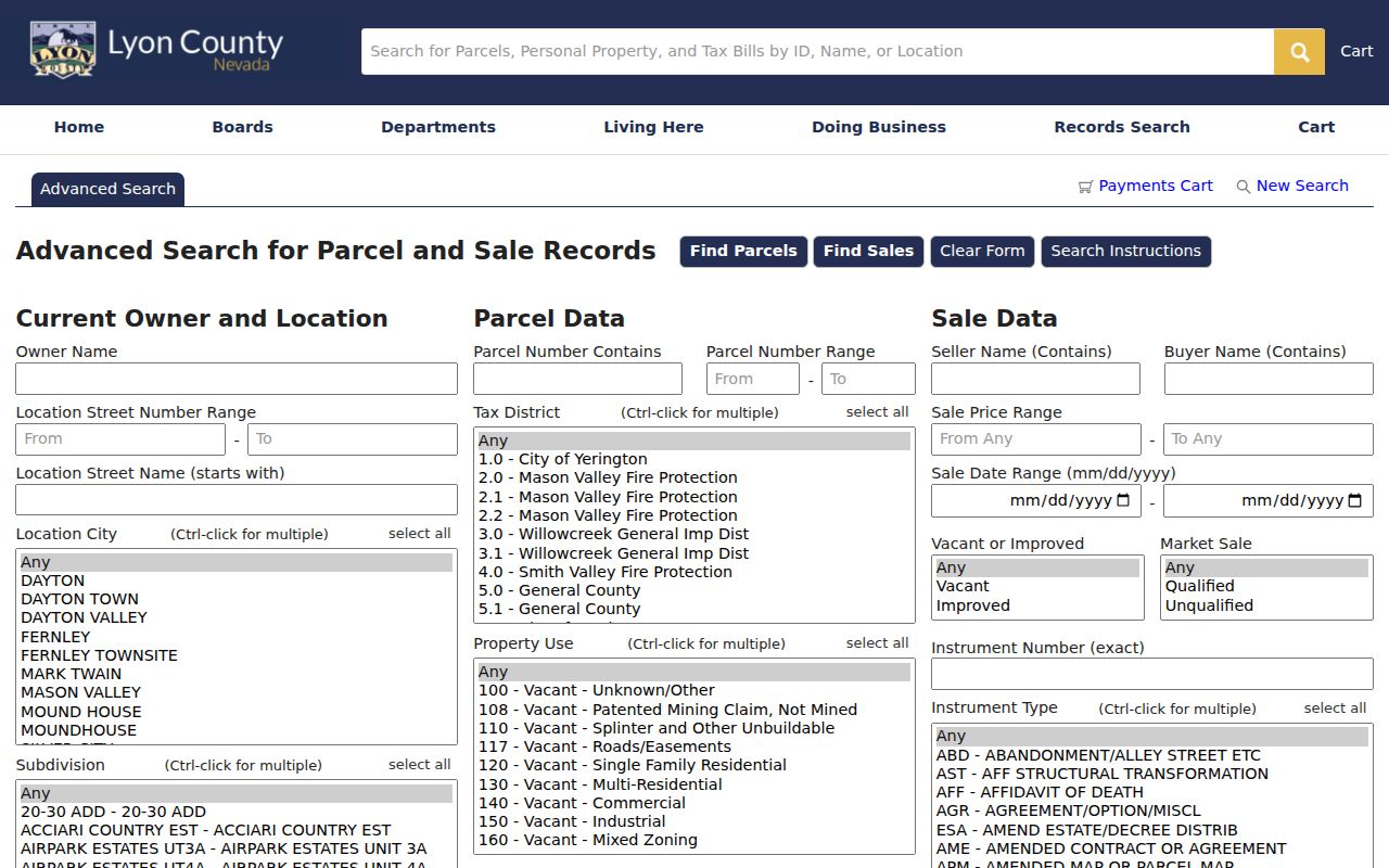
The screen shows why a street directory search can be refined by city, parcel, construction, and sale details without turning the result into a list of household members.
| Field label | Type | Required | Options or format notes |
|---|---|---|---|
| Owner Name | text | optional | current-owner search; exact matching behavior not stated |
| Location Street Number From/To | numeric pair | optional | whole-street or range search |
| Location Street Name (starts with) | text | optional | starts-with |
| Location City | multi-select | optional | Ctrl-click multiple |
| Subdivision | multi-select | optional | Ctrl-click multiple |
| Neighborhood | multi-select | optional | Ctrl-click multiple |
| Parcel Number Contains | text | optional | substring |
| Parcel Number Range From/To | text pair | optional | APN range |
| Tax District | multi-select | optional | Ctrl-click multiple |
| Property Use | multi-select | optional | Ctrl-click multiple; full live options not exposed |
| Zone | multi-select | optional | Ctrl-click multiple |
| Commercial SqFt From/To | numeric pair | optional | range |
| Residential SqFt From/To | numeric pair | optional | range |
| Acreage From/To | numeric pair | optional | range |
| Original Constr Year From/To | year pair | optional | range |
| Has Well | select | optional | options not exposed |
| Has Septic | select | optional | options not exposed |
| Seller Name (Contains) | text | optional | substring |
| Buyer Name (Contains) | text | optional | substring |
| Sale Price From Any/To Any | numeric pair | optional | range |
| Sale Date From/To | date pair | optional | mm/dd/yyyy |
| Vacant or Improved | select | optional | options not exposed |
| Market Sale | select | optional | options not exposed |
| Instrument Number (exact) | text | optional | exact |
| Instrument Type | multi-select | optional | Ctrl-click multiple; options not exposed |
| Buttons | controls | n/a | Find Parcels; Find Sales; Clear Form; Search Instructions |
Note: Assessment data can change before final tax certification, and the county says its maps are assessment tools rather than surveys.
Fernley GIS Street Parcel Details
The Lyon County GIS map begins with a property ID, address, or owner search. Select Search, then Details, to open the selected parcel. Zooming along a road and clicking nearby polygons supplies the visual side of a Fernley street directory search. It helps separate adjacent parcels and see their shape. The mapped layer includes parcel geometry and assessment-linked fields such as APN, mailing ZIP, legal owner, vesting-document information, and values.
Use the assessor form for a sortable street-number range. Use GIS for shape and adjacency. The separate map-GIS interface has a Buffer Selection distance field and unit selector, but the captured source did not reveal the live unit labels. A parcel next to another parcel on screen is not by itself proof of a shared boundary, ownership, or household connection.
- Parcel
- A defined piece of land used in assessment records and identified by an APN, or assessor parcel number.
- Situs address
- The physical property location. It differs from the mailing address used for tax notices.
- Plat
- A recorded map showing a subdivision, lots, blocks, boundaries, or other mapped land reference.
- Criss-cross directory
- A historical directory arranged by street and number to occupant when the particular volume includes that section.
Fernley Street Deeds and Plats
A deed chain is not reliably a modern street-address search. Start from the APN and legal description returned by the assessor, then find the current vesting document in the recorder index. A grantor is the party transferring an interest, often the seller. A grantee receives it, often the buyer. Read the recording date, document type, document number, book and page, APN or legal description, and the parties. Then search the prior grantor as an earlier grantee. Compare the legal description at each link, especially when a subdivision was split or an address has changed.
The Lyon County Recorder online-records guidance says document images from 1970 to the present are available online, but the search instructions also say pre-2000 documents cannot yet be viewed online. Treat that as an access inconsistency for a particular record, not as a reason to assume an image exists. The index can still give a party name, document number, and date for older work. For an official copy, use the counter, mail, email at records@lyon-county.org, fax at 775-463-5305, phone at 775-463-6581, or the request form. Copies are $1 per page, certification adds $4 per document, faxed copies are $3 per page, and a staff search carries a $10 fee. Certified copies are mailed or picked up.
Map books and recorded plats bridge a street name to lot, block, subdivision, section, township, range, or metes-and-bounds description. Assessor map books include multiple numbered volumes, and book 016 has an index, detail pages, parcel boundaries, block numbers, and recorded map references. Use those identifiers in recorder research instead of relying on a street number alone.
Fernley Street Permit History
Permit and code files supply an address timeline, not a resident roster. The City Online Permit Center can show a permit or reference number, record type, address, submitted date, expiration, and status. A county Community Development request can cover permits, site plans, septic material, floor plans, land-use permits, zoning records, and investigation records. Some site plans and investigation material have restrictions, and inspection requires an appointment.
Lyon County says building records begin in 1969 and planning and zoning records begin in 1971 or 1972. A project date may help date construction, a roof, an addition, or a change in use. An owner, applicant, or contractor named in a permit is evidence of that project role only. It does not establish who occupied an address at another time. County copy charges listed for this material are $0.25 for 8.5-by-11 black-and-white pages and $0.50 for 11-by-17 or 12-by-18 pages.
Fernley Street Addresses and Boundaries
Fernley is entirely in Lyon County after the 2005 county-boundary change, but earlier material can carry Lyon or Washoe County indexing. City limits, a postal ZIP, tax jurisdiction, fire service, sheriff service, and utility service are separate layers. A Fernley mailing name does not resolve every jurisdiction question. For early records, search locality, township, station, rural-route, and both county variants when the expected county file is silent.
City Engineering and GIS maintain address requests, GIS data requests, boundary maps, ward and precinct maps, street-index maps, and street materials. Engineering and Public Works can be reached at 775-784-9910, with the GIS Technician listed at 775-784-9826. No official dated citywide renumbering or renaming list was located. Ask that office for an old-to-current address bridge or historic street-naming approval when a legal description and street search no longer agree. Fernley first appears in Southern Pacific timetable evidence in 1904, while city sources use 1904 and 1906 as differing community milestones.
Fernley Street Directory Record Coverage
These address-keyed sources serve different purposes. The assessor and GIS establish the parcel frame. Recorder records trace a transfer. Maps and plats translate a street location into legal land language. Permits date work. Voter and historical sources have separate access rules and should not be used to fill gaps with assumptions. The coverage below keeps each Fernley street directory source in its proper lane.
| Record set | Keeper | What it shows | Access |
|---|---|---|---|
| Assessor parcel | Lyon Assessor | owner, mailing and situs address, APN, values, exemptions, use | online advanced search |
| GIS parcel | Lyon GIS and Assessor | geometry, adjacent parcels, mapped fields, layers | map viewer or REST layer |
| Recorder deed | Lyon Recorder | transfer parties, legal description, date, book, page, document | index, images, or copy request |
| Plat or map book | Assessor and Recorder | lot, block, subdivision, parcel boundaries, map references | map books or counter |
| Tax account | Assessor, Clerk, or Treasurer | tax year, balance, delinquency, district | tax search or request |
| Permit or code file | City or County Development | address, work, applicant or contractor, dates, status | permit portal or request |
| Voter list | Nevada SOS and Lyon Clerk | lawful registered-voter list fields and status | identity portal or bulk request |
| Reverse directory | Library or archive | historical occupant and address where a volume exists | collection or institutional request |
| Utility district | City utility or public district | public infrastructure and service area | public maps or request; customer identity closed |
Parcel and legal-description terms can persist when an address changes. Street labels are still useful for finding a starting record, but the APN and recorded description are the safer bridge across systems.
Note: The property record is strongest for land ownership and assessment, while resident identity needs a separate official source and context.
Fernley Street Voter Access Rules
Nevada Secretary of State My Voter File is an individual verification service. It asks for first name, last name, date of birth, and either a Nevada driver-license or identification number, or the last four digits of a Social Security number. It is not a public way to browse a Fernley street. The service can verify registration and present voter-service information for the person whose identity details are supplied.
NRS 293.440 permits a person to apply to the county clerk for a copy of a precinct, district, or county registered-voter list at one cent per name. Request the current Lyon Clerk/Treasurer form, delivery format, and any required certification instead of assuming a download exists. NRS 293.557 and 293.558 also limit disclosure: identification numbers, full date of birth, and signatures are not public, and voters may seek address and telephone withholding. Confidential Address Program and other protected records can make a missing result ambiguous.
Fernley Street Directory History Sources
No verified Fernley reverse-directory run was located. Historical street work therefore begins with the actual fallback chain: Fernley Branch Library catalog and staff, interlibrary loan, UNLV newspaper holdings, UNR regional directory material, and the Library of Congress city and telephone directory inventory. A reverse or criss-cross volume, if located, should be read first for the exact street spelling and number, then paired with the ordinary alphabetical section when the volume provides it.
Regional collections can preserve a name, address, household notation, or occupation, but coverage of Fernley must be confirmed volume by volume. The historical collections and their access limits are detailed in the Fernley city directory collections. Newspapers and regional material can suggest a lead; deeds, assessor data, and an identified original volume are the appropriate checks before treating the lead as a fact.
Fernley Street Directory Limits
A by-address property search cannot identify all residents of a house, apartment, or parcel. Non-owner household members, private utility customers, DMV addresses, protected voter addresses, and sealed court or vital material are not ordinary public street records. Multiple households can be associated with a parcel, and an assessed owner may have a different mailing location. Old street records can be incomplete because Fernley was a locality before later municipal changes and because historical collections have uneven coverage.
Fernley Parcel Count in Context
Lyon County reported approximately 34,803 parcels as of June 2025. That number explains why an address-first search is more reliable than trying to infer a neighborhood from a single name. It also underscores the difference between a parcel system and a residents directory. Parcel data links land, ownership, values, and recorded references. It cannot turn every property into a verified list of the people who live there.
Fernley’s municipal record trail is newer than the county’s. The town board dates to 1985, incorporation took effect July 1, 2001, and separate municipal court operations began in October 2002. A street question that reaches into an older period may need county, railroad, newspaper, library, and regional sources rather than a city file alone.